Jianshih Township, Hsinchu County, Tai-an Township, Miaoli County
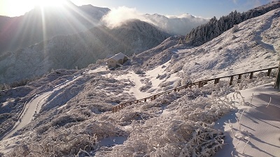
Mt. Dabajian Summit Trail
The main peak of Dabajian Mountain, part of the Snow Maintain Range, is 3,505m above sea level. Revered as the Unique Mountain of the Century because of its majestic formation, it has been the holy mountain for the Atayal and Saisiyat indigenous peoples and is referred to along with Zhongyangjian Mountain and Dafenjian Mountain as the three Taiwan Peaks. In spring, Taiwan alpine rhododendron blossoms between the 3050 Highlands and Zhongbaping. In late autumn, Taiwan pieris trees turn the valley into fiery red. There are different charms in different seasons.
06/21 Sun.
Open
27°
24° / 30°
苗栗縣 / 泰安鄉
More
Weather Forecast
|
09.16
Thur.
|
09.17
Fri.
|
09.18
Sat.
|
09.19
Sun.
|
09.20
Mon.
|
09.21
Tue.
|
09.22
Wed.
|
|
|---|---|---|---|---|---|---|---|
| Temperature |
24 ° / 30 °
|
23 ° / 31 °
|
23 ° / 30 °
|
23 ° / 31 °
|
23 ° / 31 °
|
23 ° / 30 °
|
23 ° / 31 °
|
| Feel like | 28 ° / 36 ° | 26 ° / 36 ° | 26 ° / 35 ° | 27 ° / 36 ° | 27 ° / 37 ° | 26 ° / 36 ° | 26 ° / 36 ° |
|
Probability of Precipitation |
30 % | 20 % | 30 % | - | - | - | - |
| Relative Humidity | 91 % | 89 % | 88 % | 89 % | 89 % | 88 % | 88 % |
|
Wind speed Wind direction |
-
SW
|
2
SW
|
2
SW
|
2
SW
|
-
SW
|
2
SW
|
2
SW
|
| UVI |
8
Very High
|
8
Very High
|
8
Very High
|
9
Very High
|
8
Very High
|
8
Very High
|
8
Very High
|
|
Sunrise Sunset |
|
|
|
|
|
|
|
Central Weather Bureau|Update Time:2021/09/16 11:17
Jianshih Township, Hsinchu County, Tai-an Township, Miaoli County
Mt. Dabajian Summit Trail
Learn about the Trail
Trail difficulty level
| Hiking Level |
|
|
|
|
|
|
|
||||||||||||||||||||||||||||||||||||||||||
|---|---|---|---|---|---|---|---|---|---|---|---|---|---|---|---|---|---|---|---|---|---|---|---|---|---|---|---|---|---|---|---|---|---|---|---|---|---|---|---|---|---|---|---|---|---|---|---|---|---|
| Target | General Public | General Public | Those who have better physical energy | Beginner mountain climber with good physical energy and map literacy. | Open to those who have good physical strength, map reading skills, and wild survival skills. | Open to well-trained mountain climbers. | Open to well-trained mountain climbers. | ||||||||||||||||||||||||||||||||||||||||||
| Elevation | Gently sloping area | In recreational areas, close to settlements or about 1,000 meters above sea level. | In recreational areas, close to settlements or between 1,000~2,000 meters above sea level. | Remote areas or between 2,000 to 3,000 meters above sea level | Remote areas, wilderness, or between 2,000 to 3,000 meters above sea level | Remote areas, wilderness, or more than 3,000 meters above sea level | Remote areas, wilderness, or more than 3,000 meters above sea level | ||||||||||||||||||||||||||||||||||||||||||
| Required Time | It takes half to one day. | It takes half to one day. | It can be done within one day. | It takes one or more days. | Overnight preparation required. | It takes up to three days. | It takes up to three days. | ||||||||||||||||||||||||||||||||||||||||||
| Equipment | Light backpacking (water and small amount of food) | Light backpacking (water and small amount of food) | Light backpacking (water and proper amount of food) | Overnight preparation required. (e.g. drinking water, food, map, warm clothing, first-aid medicine, etc.) Application for entrance permission in advance is required if there is access control. | Comprehensive Mountaineering Gear Required. (e.g. food, drinking water, cooking utensils, map, warm clothing, flashlight, sleeping bag, tent, etc.) Application for entrance permission in advance is required if there is access control. | Comprehensive Mountaineering Gear Required. (e.g. food, drinking water, cooking utensils, map, warm clothing, flashlight, sleeping bag, tent, etc.) Application for entrance permission in advance is required if there is access control. | Comprehensive Mountaineering Gear Required. (e.g. food, drinking water, cooking utensils, map, warm clothing, flashlight, sleeping bag, tent, etc.) Application for entrance permission in advance is required if there is access control. | ||||||||||||||||||||||||||||||||||||||||||
| Description | Flat hiking trails. Relatively even slopes with comprehensive facilities and smooth road surface. Accessible for handicapped assistive devices or baby strollers. | An open hiking trail with easy access. Relatively even slopes with comprehensive facilities and smooth road surface. It takes half a day or less than one day to complete. | An open hiking trail with easy access. Somewhat steep slope with some difficult sections, but has comprehensive facilities and smooth road surface. It takes less than one day to complete. | A hiking trail locates at remote area or with part of the route is in area which requires entrance permission. Application in advance is required. Part of the route is in relatively bad condition with steeper slopes, but basic facilities are provided. It takes one day or between one to three days to complete. | A hiking trail locates at remote area or with part of the route is in area which requires entrance permission. It’s located in high-altitude areas (higher than 3000 meters above sea level). The trail is relatively primitive, with steeper slopes and unstable weather conditions. Part of the route may be dangerous or difficult for climbers. It takes two to three days to complete. Lead from professionals is recommended. | A hiking trail locates at area with inconvenient traffic, and mostly with routes in area which requires entrance permission. It’s located in high-altitude areas (higher than 3000 meters above sea level). The trail is located at primitive area, with bad condition, steeper slopes, and unstable weather conditions. Many parts of the route may be dangerous or difficult for climbers. It takes three or more days to complete. Lead from professionals is recommended. | 1. Level 3, 4 or 5 trails when snow or ice accumulating 2. Informal trails, without clear subgrades or paths, belong to special routes such as original mountain trails, ancient trail relics, prospecting, or technical climbing. |
Hiking Level
Target
General Public
Elevation
Gently sloping area
Required Time
It takes half to one day.
Equipment
Light backpacking (water and small amount of food)
Description
Flat hiking trails. Relatively even slopes with comprehensive facilities and smooth road surface. Accessible for handicapped assistive devices or baby strollers.
Hiking Level
Target
General Public
Elevation
In recreational areas, close to settlements or about 1,000 meters above sea level.
Required Time
It takes half to one day.
Equipment
Light backpacking (water and small amount of food)
Description
An open hiking trail with easy access. Relatively even slopes with comprehensive facilities and smooth road surface. It takes half a day or less than one day to complete.
Hiking Level
Target
Those who have better physical energy
Elevation
In recreational areas, close to settlements or between 1,000~2,000 meters above sea level.
Required Time
It can be done within one day.
Equipment
Light backpacking (water and proper amount of food)
Description
An open hiking trail with easy access. Somewhat steep slope with some difficult sections, but has comprehensive facilities and smooth road surface. It takes less than one day to complete.
Hiking Level
Target
Beginner mountain climber with good physical energy and map literacy.
Elevation
Remote areas or between 2,000 to 3,000 meters above sea level
Required Time
It takes one or more days.
Equipment
Overnight preparation required. (e.g. drinking water, food, map, warm clothing, first-aid medicine, etc.)
Application for entrance permission in advance is required if there is access control.
Description
A hiking trail locates at remote area or with part of the route is in area which requires entrance permission. Application in advance is required. Part of the route is in relatively bad condition with steeper slopes, but basic facilities are provided. It takes one day or between one to three days to complete.
Hiking Level
Target
Open to those who have good physical strength, map reading skills, and wild survival skills.
Elevation
Remote areas, wilderness, or between 2,000 to 3,000 meters above sea level
Required Time
Overnight preparation required.
Equipment
Comprehensive Mountaineering Gear Required. (e.g. food, drinking water, cooking utensils, map, warm clothing, flashlight, sleeping bag, tent, etc.)
Application for entrance permission in advance is required if there is access control.
Description
A hiking trail locates at remote area or with part of the route is in area which requires entrance permission. It’s located in high-altitude areas (higher than 3000 meters above sea level). The trail is relatively primitive, with steeper slopes and unstable weather conditions. Part of the route may be dangerous or difficult for climbers. It takes two to three days to complete. Lead from professionals is recommended.
Hiking Level
Target
Open to well-trained mountain climbers.
Elevation
Remote areas, wilderness, or more than 3,000 meters above sea level
Required Time
It takes up to three days.
Equipment
Comprehensive Mountaineering Gear Required. (e.g. food, drinking water, cooking utensils, map, warm clothing, flashlight, sleeping bag, tent, etc.)
Application for entrance permission in advance is required if there is access control.
Description
A hiking trail locates at area with inconvenient traffic, and mostly with routes in area which requires entrance permission. It’s located in high-altitude areas (higher than 3000 meters above sea level). The trail is located at primitive area, with bad condition, steeper slopes, and unstable weather conditions. Many parts of the route may be dangerous or difficult for climbers. It takes three or more days to complete. Lead from professionals is recommended.
Hiking Level
Target
Open to well-trained mountain climbers.
Elevation
Remote areas, wilderness, or more than 3,000 meters above sea level
Required Time
It takes up to three days.
Equipment
Comprehensive Mountaineering Gear Required. (e.g. food, drinking water, cooking utensils, map, warm clothing, flashlight, sleeping bag, tent, etc.)
Application for entrance permission in advance is required if there is access control.
Description
1. Level 3, 4 or 5 trails when snow or ice accumulating
2. Informal trails, without clear subgrades or paths, belong to special routes such as original mountain trails, ancient trail relics, prospecting, or technical climbing.
Reachable by Vehicle
X:Cars、Microbus、Coach Bus
Mountain system
Xue Mountains
Administer
Hsinchu Forest Dist. Office
Elevation
1,800 ~ 3,380 m
Service Line
+886 35224163 #262
Altitude Difference
1,580 m
Huts
-
Length of the Trail
11.8 KM
Entry Permit
No
Trail type
Linear one way
Via Nature Reserve
Yes
Service Line
Soil pavement,Wooden path,Stone paving stairway
Geologically Sensitive Area
Yes
Route planning
2 days
Debris Flow Torrents
No
Trail Track
Trail route
Trailhead / Trig
Mobile coverage
Observations (From iNaturalist)
Trailhead / Trig
Mobile coverage
Observations (From iNaturalist)
Reminders
Application for mountain entry control instructions
There is a "Dabajian Mountain Climbing Service Station" at 0.4K of the east entrance of Dalu Forest Road. Please drop your admission pass into the mailbox before entering, or use the Shei-Pa Park App to check in. Jiujiu Mountain Villa provides accommodation and catering services. If you need to hire a mountaineering assistant, reserve meals, or rent a sleeping bag, please contact the mountaineering cooperative group. Those who do not reserve meals must bring their own food and water. Jiujiu Mountain Villa telephone number is (03) 522-4163 ext. 264 (service hours are 8:00-12:00 am and 1:00-5:00 pm. Closed on Saturdays, Sundays, and national holidays). There are two mountaineering cooperative groups. Please contact Mr. Quan of "Bunong Caribu Bay Enterprise" at 0921-486289; Ms. Lin of "Hsinchu County Aboriginal Youth Association" at 0966-123501 or the Original Force Team at 0972-053685.
Travel with others and don’t take shortcuts
For your own safety, please travel with a group, follow the signs, do not take shortcuts or create your own route, and do not wander alone.
Carry GPS positioning system and communication equipment
Please plan your itinerary properly and bring enough equipment and food for hiking. It is recommended to bring a global satellite positioning system (GPS) and communication equipment such as satellite phones, mobile phones, radios or equipment with satellite positioning functions such as personal location trackers (PLBs), etc., and bring enough batteries to ensure emergency communication.
Pass through danger quickly
The road conditions in the mountains are unstable. Please do not stop or take photos in dangerous places such as landslides or rockfall areas, and pay attention to your own safety at all times.
It is recommended to purchase mountaineering insurance
Mountain activities have certain risks. It is recommended that you purchase mountaineering insurance before departure. (Note: General travel insurance does not necessarily cover mountaineering accidents. It is recommended to read the policy carefully before purchasing. For mountaineering insurance, please refer to the following press release of the Financial Supervisory Commission and choose the appropriate policy to purchase)
Mountaineering insurance sold by property and casualty insurance companies has expanded coverage to include search and rescue expenses
Please click the link below for content
Mountaineering safety information
For information on mountaineering safety knowledge, mountaineering equipment, map usage skills, etc., please see the mountaineering supply station webpage below. It is recommended to read it before the trip to ensure the safety of your outdoor activities.
【Pay special attention to altitude sickness】
The trail reaches an altitude of over 2,500 meters. Anyone may be at risk of mountain sickness. It is recommended to assess your physical and physiological condition before departure and prepare personal medicines. For an introduction to mountain sickness, please see the following article. For relevant knowledge on mountain medicine, please see the following video (produced by the Taiwan Wilderness Emergency Rescue Association).
Hiking Notes - [10 Questions You Must Know About Altitude Sickness] Written by Dr. Wang Shihao
Please click below for the article content
Hiking Notes - [On-site judgment and self-diagnosis of mountain sickness] Written by Dr. Wang Shihao
Please click below for the article content
Recommended Equipment
Dabajian Mountain Hiking Trail_Suggested Equipment List for Multi-Day Hiking Trails
Mountain Encyclopedia
Please click below to view information
Travel Guide

Travel Guide
Nearby Attractions
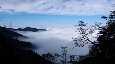
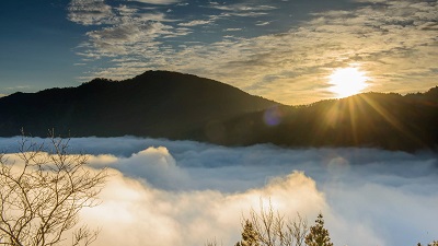
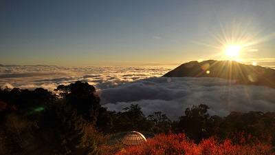
Guanwu National Forest Recreation Area
Located in Taiwan's cloud belt, the clouds often linger in the valleys, hence the name. The ever-changing sea of clouds, sunrise, sunset, and the magnificent Holy Ridge are the most famous scenery. There are three trails in the park, namely, Zhenshan, Huishan Giant Tree Group, and Guanwu Waterfall, each with its own characteristics; the thousand-year-old red cypress giant trees and flowers blooming all year round; and the rare Dimuhua Impatiens, Guanwu Salamander and Broad-tailed Swallowtail Butterfly, which add a lot of color to Guanwu.
Qingquan Tribe
It is a tribe of the Atayal people. Because of the hot springs gushing out of the valley, the Atayal people called it "ulay-mkilix". During the Japanese colonial period, the Japanese developed the hot springs and renamed it Inoue. It was once one of the eight scenic spots in Hsinchu. It was renamed Qingquan after Taiwan's restoration. The writer Sanmao once rented a house in Qingquan and named it "Dream House". The house still exists today. The "Inoue Hot Spring Sanatorium" where Zhang Xueliang was imprisoned has been washed away by typhoon landslides.
Travel Advice
Stay at a guesthouse or farm near Guanwu the night before. Day 1/Guanwu→Follow the East Trail of Dalulin Road to reach the entrance of Madara Creek→camp at Jiujiu Villa. Day 2/From Jiujiu Villa→climb Jiali Mountain, Yize Mountain, Xiaobajian Mountain and Dabajian Mountain according to your physical strength→camp at Jiujiu Villa. Day 3/Return to Jiujiu Villa.
Nearby Attractions