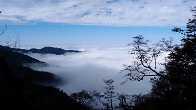
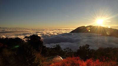
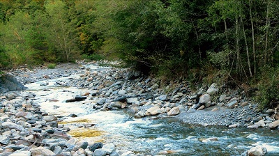
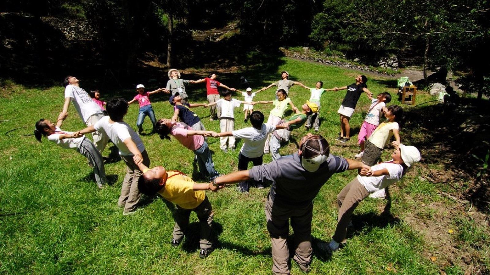
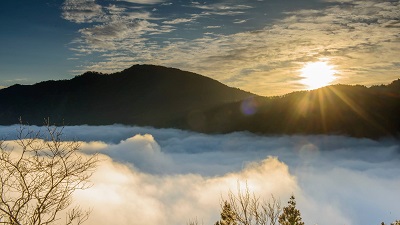
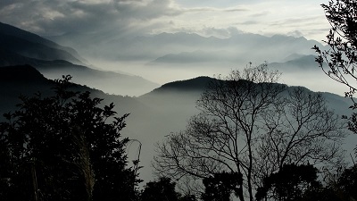
The Jialishan Trail connects Nanzhuang Penglai, Fengmei and Luchang. Along the way are Japanese cedar plantations and broadleaf forests. The forest-floor vegetation is mostly ferns and shade-tolerant species. The Fengmei Creek runs through the forests where there are a large variety of animals and plants. The trolley track used during the lumbering period is still lying there to attest to the prosperity of the lumbering industry back then. There is a Class 1 triangulation station at the top from which the magnificent Snow Mountain Holy Ridgeline and the Luchang Mountain can be seen in the distance.
06/21 Sun.
Open
28°
24° / 31°
苗栗縣 / 南庄鄉
More
Weather Forecast
|
09.16
Thur.
|
09.17
Fri.
|
09.18
Sat.
|
09.19
Sun.
|
09.20
Mon.
|
09.21
Tue.
|
09.22
Wed.
|
|
|---|---|---|---|---|---|---|---|
| Temperature |
24 ° / 31 °
|
23 ° / 31 °
|
23 ° / 31 °
|
23 ° / 31 °
|
23 ° / 31 °
|
23 ° / 32 °
|
23 ° / 32 °
|
| Feel like | 28 ° / 37 ° | 26 ° / 38 ° | 27 ° / 37 ° | 26 ° / 38 ° | 27 ° / 38 ° | 27 ° / 38 ° | 27 ° / 38 ° |
|
Probability of Precipitation |
20 % | 30 % | 40 % | - | - | - | - |
| Relative Humidity | 91 % | 89 % | 89 % | 89 % | 90 % | 88 % | 89 % |
|
Wind speed Wind direction |
2
W
|
2
SW
|
2
SW
|
2
N
|
2
S
|
2
S
|
2
NE
|
| UVI |
8
Very High
|
8
Very High
|
8
Very High
|
9
Very High
|
8
Very High
|
8
Very High
|
8
Very High
|
|
Sunrise Sunset |
|
|
|
|
|
|
|
Central Weather Bureau|Update Time:2021/09/16 11:17
Nanjhuang Township, Miaoli County
Mt. Jiali Summit Trail
Learn about the Trail
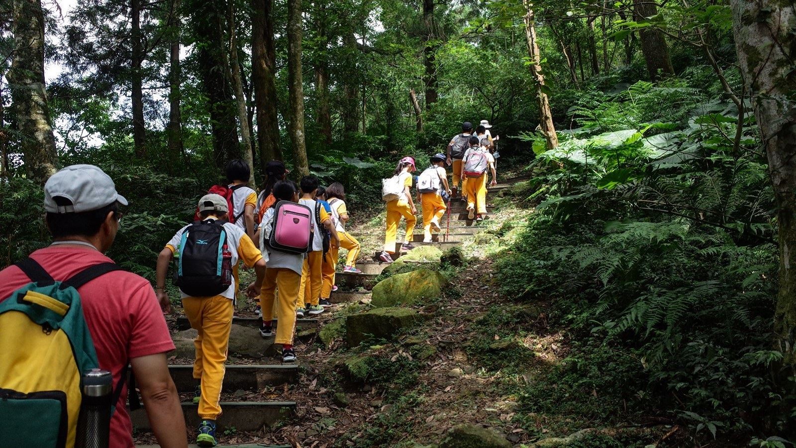
Trail difficulty level
| Hiking Level |
|
|
|
|
|
|
|
||||||||||||||||||||||||||||||||||||||||||
|---|---|---|---|---|---|---|---|---|---|---|---|---|---|---|---|---|---|---|---|---|---|---|---|---|---|---|---|---|---|---|---|---|---|---|---|---|---|---|---|---|---|---|---|---|---|---|---|---|---|
| Target | General Public | General Public | Those who have better physical energy | Beginner mountain climber with good physical energy and map literacy. | Open to those who have good physical strength, map reading skills, and wild survival skills. | Open to well-trained mountain climbers. | Open to well-trained mountain climbers. | ||||||||||||||||||||||||||||||||||||||||||
| Elevation | Gently sloping area | In recreational areas, close to settlements or about 1,000 meters above sea level. | In recreational areas, close to settlements or between 1,000~2,000 meters above sea level. | Remote areas or between 2,000 to 3,000 meters above sea level | Remote areas, wilderness, or between 2,000 to 3,000 meters above sea level | Remote areas, wilderness, or more than 3,000 meters above sea level | Remote areas, wilderness, or more than 3,000 meters above sea level | ||||||||||||||||||||||||||||||||||||||||||
| Required Time | It takes half to one day. | It takes half to one day. | It can be done within one day. | It takes one or more days. | Overnight preparation required. | It takes up to three days. | It takes up to three days. | ||||||||||||||||||||||||||||||||||||||||||
| Equipment | Light backpacking (water and small amount of food) | Light backpacking (water and small amount of food) | Light backpacking (water and proper amount of food) | Overnight preparation required. (e.g. drinking water, food, map, warm clothing, first-aid medicine, etc.) Application for entrance permission in advance is required if there is access control. | Comprehensive Mountaineering Gear Required. (e.g. food, drinking water, cooking utensils, map, warm clothing, flashlight, sleeping bag, tent, etc.) Application for entrance permission in advance is required if there is access control. | Comprehensive Mountaineering Gear Required. (e.g. food, drinking water, cooking utensils, map, warm clothing, flashlight, sleeping bag, tent, etc.) Application for entrance permission in advance is required if there is access control. | Comprehensive Mountaineering Gear Required. (e.g. food, drinking water, cooking utensils, map, warm clothing, flashlight, sleeping bag, tent, etc.) Application for entrance permission in advance is required if there is access control. | ||||||||||||||||||||||||||||||||||||||||||
| Description | Flat hiking trails. Relatively even slopes with comprehensive facilities and smooth road surface. Accessible for handicapped assistive devices or baby strollers. | An open hiking trail with easy access. Relatively even slopes with comprehensive facilities and smooth road surface. It takes half a day or less than one day to complete. | An open hiking trail with easy access. Somewhat steep slope with some difficult sections, but has comprehensive facilities and smooth road surface. It takes less than one day to complete. | A hiking trail locates at remote area or with part of the route is in area which requires entrance permission. Application in advance is required. Part of the route is in relatively bad condition with steeper slopes, but basic facilities are provided. It takes one day or between one to three days to complete. | A hiking trail locates at remote area or with part of the route is in area which requires entrance permission. It’s located in high-altitude areas (higher than 3000 meters above sea level). The trail is relatively primitive, with steeper slopes and unstable weather conditions. Part of the route may be dangerous or difficult for climbers. It takes two to three days to complete. Lead from professionals is recommended. | A hiking trail locates at area with inconvenient traffic, and mostly with routes in area which requires entrance permission. It’s located in high-altitude areas (higher than 3000 meters above sea level). The trail is located at primitive area, with bad condition, steeper slopes, and unstable weather conditions. Many parts of the route may be dangerous or difficult for climbers. It takes three or more days to complete. Lead from professionals is recommended. | 1. Level 3, 4 or 5 trails when snow or ice accumulating 2. Informal trails, without clear subgrades or paths, belong to special routes such as original mountain trails, ancient trail relics, prospecting, or technical climbing. |
Hiking Level
Target
General Public
Elevation
Gently sloping area
Required Time
It takes half to one day.
Equipment
Light backpacking (water and small amount of food)
Description
Flat hiking trails. Relatively even slopes with comprehensive facilities and smooth road surface. Accessible for handicapped assistive devices or baby strollers.
Hiking Level
Target
General Public
Elevation
In recreational areas, close to settlements or about 1,000 meters above sea level.
Required Time
It takes half to one day.
Equipment
Light backpacking (water and small amount of food)
Description
An open hiking trail with easy access. Relatively even slopes with comprehensive facilities and smooth road surface. It takes half a day or less than one day to complete.
Hiking Level
Target
Those who have better physical energy
Elevation
In recreational areas, close to settlements or between 1,000~2,000 meters above sea level.
Required Time
It can be done within one day.
Equipment
Light backpacking (water and proper amount of food)
Description
An open hiking trail with easy access. Somewhat steep slope with some difficult sections, but has comprehensive facilities and smooth road surface. It takes less than one day to complete.
Hiking Level
Target
Beginner mountain climber with good physical energy and map literacy.
Elevation
Remote areas or between 2,000 to 3,000 meters above sea level
Required Time
It takes one or more days.
Equipment
Overnight preparation required. (e.g. drinking water, food, map, warm clothing, first-aid medicine, etc.)
Application for entrance permission in advance is required if there is access control.
Description
A hiking trail locates at remote area or with part of the route is in area which requires entrance permission. Application in advance is required. Part of the route is in relatively bad condition with steeper slopes, but basic facilities are provided. It takes one day or between one to three days to complete.
Hiking Level
Target
Open to those who have good physical strength, map reading skills, and wild survival skills.
Elevation
Remote areas, wilderness, or between 2,000 to 3,000 meters above sea level
Required Time
Overnight preparation required.
Equipment
Comprehensive Mountaineering Gear Required. (e.g. food, drinking water, cooking utensils, map, warm clothing, flashlight, sleeping bag, tent, etc.)
Application for entrance permission in advance is required if there is access control.
Description
A hiking trail locates at remote area or with part of the route is in area which requires entrance permission. It’s located in high-altitude areas (higher than 3000 meters above sea level). The trail is relatively primitive, with steeper slopes and unstable weather conditions. Part of the route may be dangerous or difficult for climbers. It takes two to three days to complete. Lead from professionals is recommended.
Hiking Level
Target
Open to well-trained mountain climbers.
Elevation
Remote areas, wilderness, or more than 3,000 meters above sea level
Required Time
It takes up to three days.
Equipment
Comprehensive Mountaineering Gear Required. (e.g. food, drinking water, cooking utensils, map, warm clothing, flashlight, sleeping bag, tent, etc.)
Application for entrance permission in advance is required if there is access control.
Description
A hiking trail locates at area with inconvenient traffic, and mostly with routes in area which requires entrance permission. It’s located in high-altitude areas (higher than 3000 meters above sea level). The trail is located at primitive area, with bad condition, steeper slopes, and unstable weather conditions. Many parts of the route may be dangerous or difficult for climbers. It takes three or more days to complete. Lead from professionals is recommended.
Hiking Level
Target
Open to well-trained mountain climbers.
Elevation
Remote areas, wilderness, or more than 3,000 meters above sea level
Required Time
It takes up to three days.
Equipment
Comprehensive Mountaineering Gear Required. (e.g. food, drinking water, cooking utensils, map, warm clothing, flashlight, sleeping bag, tent, etc.)
Application for entrance permission in advance is required if there is access control.
Description
1. Level 3, 4 or 5 trails when snow or ice accumulating
2. Informal trails, without clear subgrades or paths, belong to special routes such as original mountain trails, ancient trail relics, prospecting, or technical climbing.
Reachable by Vehicle
O:Cars , X:Microbus、Coach Bus
Mountain system
Jiali Mountain
Administer
Hsinchu Forest Dist. Office
Elevation
1,350 ~ 2,220 m
Service Line
+886 35224163 #262
Altitude Difference
870 m
Huts
-
Length of the Trail
6.8 KM
Entry Permit
No
Trail type
Ring
Via Nature Reserve
No
Road condition
-
Geologically Sensitive Area
Yes
Route planning
1 day
Debris Flow Torrents
No
Trail Track
Trail route
Trailhead / Trig
Mobile coverage
Observations (From iNaturalist)
Trailhead / Trig
Mobile coverage
Observations (From iNaturalist)
Reminders
Travel with others and don’t take shortcuts
For your own safety, please travel with a group, follow the signs, do not take shortcuts or create your own route, and do not wander alone.
Carry GPS positioning system and communication equipment
Please plan your itinerary properly and bring enough equipment and food for hiking. It is recommended to bring a global satellite positioning system (GPS) and communication equipment such as satellite phones, mobile phones, radios or equipment with satellite positioning functions such as personal location trackers (PLBs), etc., and bring enough batteries to ensure emergency communication.
Pass through danger zones quickly
The road conditions in the mountains are unstable. Please do not stop or take photos in dangerous places such as landslides or rockfall areas, and pay attention to your own safety at all times.
It is recommended to purchase mountaineering insurance
Mountain activities have certain risks. It is recommended that you purchase mountaineering insurance before departure. (Note: General travel insurance does not necessarily cover mountaineering accidents. It is recommended to read the policy carefully before purchasing. For mountaineering insurance, please refer to the following press release of the Financial Supervisory Commission and choose the appropriate policy to purchase)
Mountaineering insurance sold by property and casualty insurance companies has expanded coverage to include search and rescue expenses
Please click the link below for content
Mountaineering safety information
For information on mountaineering safety knowledge, mountaineering equipment, map usage skills, etc., please see the mountaineering supply station webpage below. It is recommended to read it before the trip to ensure the safety of your outdoor activities.
Recommended Equipment
Gary Mountain Hiking Trail - Suggested Equipment List for a Single Day Hiking Trail
Mountain Encyclopedia
Please click below to view information
Travel Guide

Travel Guide
Nearby Attractions
Donghe Village
It belongs to Nanzhuang Township, Miaoli County. It is the area with the largest number of Saisiyat people, as well as Hakka people and a small number of Atayal people. The rich humanities and magnificent natural landscapes are the characteristics of Donghe Village, including Xiangtian Lake, Deer Farm and Jiali Mountain. It is also one of the few places in Taiwan where Aspidistra has been restored.
Shenxian Valley
Shenxian Valley is located at the confluence of Fengmei Creek and Bilin Creek, tributaries of the upper reaches of Donghe Creek. The strong impact of the stream water creates a drop of dozens of meters between the rock beds, forming the beautiful scenery of flowing springs and waterfalls. The entrance of the trail is located next to Miaoli Route 21, and it only takes five minutes to reach. You can also use the Shenxian Valley suspension bridge to connect to the Shimen Trail on the other side.
More
Nanzhuang Old Street
Nanzhuang Township was a coal mining area in the early days and was once prosperous. Most of the attractions in Nanzhuang Old Street are concentrated in Zhongzheng Road near Yongchang Temple and the alleys next to it. The strong Hakka nostalgic style and food are the charm that attracts tourists.
More
Penglai Creek Natural Ecological Park (Fish Protection Trail)
Penglai Creek, located in Penglai Village, Nanzhuang, had its ecology destroyed by netting and poisoning fish in the early days. With the efforts of local villagers, the original ecological environment of Penglai Creek has been restored and it has become a tourist attraction, providing tourists with an opportunity to learn about the ecology of the creek and explore the results of fishery protection.
Travel Advice
Arrange a 2-day itinerary with nearby attractions.
Nearby Attractions