.JPG)


Ren-ai Township, Changhua County, XiulinTownship, Hualien County
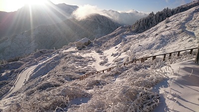
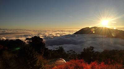
Nenggao Cross-Ridge Trail-West Section
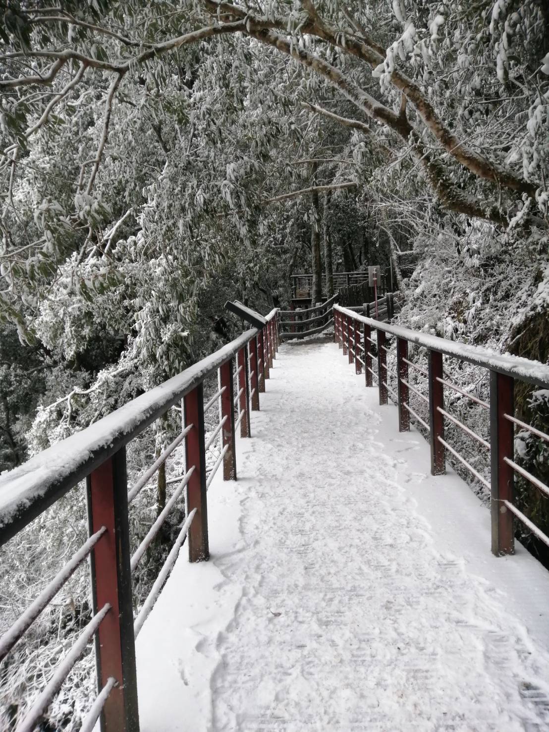
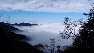
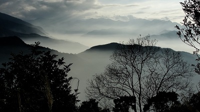
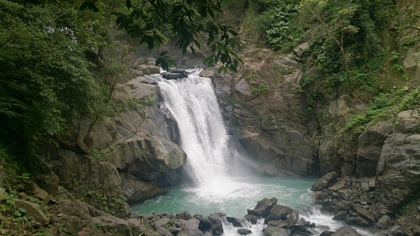
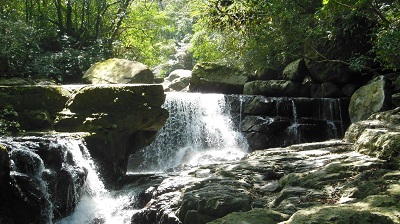
The trail begins at Renai Township in Nantou County, runs through the Qilai Series and Nenggao Series in the middle section of the Central Mountain Range, and reaches Tongmen Village in Xiulin Township, Hualien County. It parallels with the Taluowan Creek and meanders in the endless mountains. 90% of the trail passes the Danda Major Wildlife Habitat. It used to be the path the Seediq Tribesmen took to go hunting and travel and also an important defense line during the Japanese Rule. Since the recovery of Taiwan until today, it has been Taipower’s high voltage cable maintenance route. The subtropical high-mountain grassland, the magnificent formation of the Central Mountain Range, the virgin forest with gaint trees, the waterfalls and mountain springs running down the cliffs, the landslides and ravines, the high peaks and deep gorges, and the peaceful and beautiful Qilai Mountain Lake offer different high-mountain views through the seasons. It has been a very popular hiking route since the Japanese Rule Period.
06/21 Sun.
Open
25°
23° / 27°
花蓮縣 / 秀林鄉
More
Weather Forecast
|
09.16
Thur.
|
09.17
Fri.
|
09.18
Sat.
|
09.19
Sun.
|
09.20
Mon.
|
09.21
Tue.
|
09.22
Wed.
|
|
|---|---|---|---|---|---|---|---|
| Temperature |
23 ° / 27 °
|
23 ° / 28 °
|
23 ° / 27 °
|
22 ° / 27 °
|
23 ° / 27 °
|
23 ° / 28 °
|
23 ° / 27 °
|
| Feel like | 27 ° / 31 ° | 25 ° / 32 ° | 25 ° / 31 ° | 25 ° / 32 ° | 25 ° / 32 ° | 24 ° / 32 ° | 25 ° / 31 ° |
|
Probability of Precipitation |
20 % | 20 % | 30 % | - | - | - | - |
| Relative Humidity | 86 % | 88 % | 87 % | 86 % | 82 % | 82 % | 80 % |
|
Wind speed Wind direction |
2
S
|
2
SW
|
2
SW
|
2
SW
|
2
W
|
2
W
|
2
E
|
| UVI |
8
Very High
|
9
Very High
|
9
Very High
|
10
Very High
|
10
Very High
|
10
Very High
|
10
Very High
|
|
Sunrise Sunset |
|
|
|
|
|
|
|
Central Weather Bureau|Update Time:2021/09/16 11:17
Ren-ai Township, Changhua County, XiulinTownship, Hualien County
Nenggao Cross-Ridge Trail-West Section
Learn about the Trail
Trail difficulty level
| Hiking Level |
|
|
|
|
|
|
|
||||||||||||||||||||||||||||||||||||||||||
|---|---|---|---|---|---|---|---|---|---|---|---|---|---|---|---|---|---|---|---|---|---|---|---|---|---|---|---|---|---|---|---|---|---|---|---|---|---|---|---|---|---|---|---|---|---|---|---|---|---|
| Target | General Public | General Public | Those who have better physical energy | Beginner mountain climber with good physical energy and map literacy. | Open to those who have good physical strength, map reading skills, and wild survival skills. | Open to well-trained mountain climbers. | Open to well-trained mountain climbers. | ||||||||||||||||||||||||||||||||||||||||||
| Elevation | Gently sloping area | In recreational areas, close to settlements or about 1,000 meters above sea level. | In recreational areas, close to settlements or between 1,000~2,000 meters above sea level. | Remote areas or between 2,000 to 3,000 meters above sea level | Remote areas, wilderness, or between 2,000 to 3,000 meters above sea level | Remote areas, wilderness, or more than 3,000 meters above sea level | Remote areas, wilderness, or more than 3,000 meters above sea level | ||||||||||||||||||||||||||||||||||||||||||
| Required Time | It takes half to one day. | It takes half to one day. | It can be done within one day. | It takes one or more days. | Overnight preparation required. | It takes up to three days. | It takes up to three days. | ||||||||||||||||||||||||||||||||||||||||||
| Equipment | Light backpacking (water and small amount of food) | Light backpacking (water and small amount of food) | Light backpacking (water and proper amount of food) | Overnight preparation required. (e.g. drinking water, food, map, warm clothing, first-aid medicine, etc.) Application for entrance permission in advance is required if there is access control. | Comprehensive Mountaineering Gear Required. (e.g. food, drinking water, cooking utensils, map, warm clothing, flashlight, sleeping bag, tent, etc.) Application for entrance permission in advance is required if there is access control. | Comprehensive Mountaineering Gear Required. (e.g. food, drinking water, cooking utensils, map, warm clothing, flashlight, sleeping bag, tent, etc.) Application for entrance permission in advance is required if there is access control. | Comprehensive Mountaineering Gear Required. (e.g. food, drinking water, cooking utensils, map, warm clothing, flashlight, sleeping bag, tent, etc.) Application for entrance permission in advance is required if there is access control. | ||||||||||||||||||||||||||||||||||||||||||
| Description | Flat hiking trails. Relatively even slopes with comprehensive facilities and smooth road surface. Accessible for handicapped assistive devices or baby strollers. | An open hiking trail with easy access. Relatively even slopes with comprehensive facilities and smooth road surface. It takes half a day or less than one day to complete. | An open hiking trail with easy access. Somewhat steep slope with some difficult sections, but has comprehensive facilities and smooth road surface. It takes less than one day to complete. | A hiking trail locates at remote area or with part of the route is in area which requires entrance permission. Application in advance is required. Part of the route is in relatively bad condition with steeper slopes, but basic facilities are provided. It takes one day or between one to three days to complete. | A hiking trail locates at remote area or with part of the route is in area which requires entrance permission. It’s located in high-altitude areas (higher than 3000 meters above sea level). The trail is relatively primitive, with steeper slopes and unstable weather conditions. Part of the route may be dangerous or difficult for climbers. It takes two to three days to complete. Lead from professionals is recommended. | A hiking trail locates at area with inconvenient traffic, and mostly with routes in area which requires entrance permission. It’s located in high-altitude areas (higher than 3000 meters above sea level). The trail is located at primitive area, with bad condition, steeper slopes, and unstable weather conditions. Many parts of the route may be dangerous or difficult for climbers. It takes three or more days to complete. Lead from professionals is recommended. | 1. Level 3, 4 or 5 trails when snow or ice accumulating 2. Informal trails, without clear subgrades or paths, belong to special routes such as original mountain trails, ancient trail relics, prospecting, or technical climbing. |
Hiking Level
Target
General Public
Elevation
Gently sloping area
Required Time
It takes half to one day.
Equipment
Light backpacking (water and small amount of food)
Description
Flat hiking trails. Relatively even slopes with comprehensive facilities and smooth road surface. Accessible for handicapped assistive devices or baby strollers.
Hiking Level
Target
General Public
Elevation
In recreational areas, close to settlements or about 1,000 meters above sea level.
Required Time
It takes half to one day.
Equipment
Light backpacking (water and small amount of food)
Description
An open hiking trail with easy access. Relatively even slopes with comprehensive facilities and smooth road surface. It takes half a day or less than one day to complete.
Hiking Level
Target
Those who have better physical energy
Elevation
In recreational areas, close to settlements or between 1,000~2,000 meters above sea level.
Required Time
It can be done within one day.
Equipment
Light backpacking (water and proper amount of food)
Description
An open hiking trail with easy access. Somewhat steep slope with some difficult sections, but has comprehensive facilities and smooth road surface. It takes less than one day to complete.
Hiking Level
Target
Beginner mountain climber with good physical energy and map literacy.
Elevation
Remote areas or between 2,000 to 3,000 meters above sea level
Required Time
It takes one or more days.
Equipment
Overnight preparation required. (e.g. drinking water, food, map, warm clothing, first-aid medicine, etc.)
Application for entrance permission in advance is required if there is access control.
Description
A hiking trail locates at remote area or with part of the route is in area which requires entrance permission. Application in advance is required. Part of the route is in relatively bad condition with steeper slopes, but basic facilities are provided. It takes one day or between one to three days to complete.
Hiking Level
Target
Open to those who have good physical strength, map reading skills, and wild survival skills.
Elevation
Remote areas, wilderness, or between 2,000 to 3,000 meters above sea level
Required Time
Overnight preparation required.
Equipment
Comprehensive Mountaineering Gear Required. (e.g. food, drinking water, cooking utensils, map, warm clothing, flashlight, sleeping bag, tent, etc.)
Application for entrance permission in advance is required if there is access control.
Description
A hiking trail locates at remote area or with part of the route is in area which requires entrance permission. It’s located in high-altitude areas (higher than 3000 meters above sea level). The trail is relatively primitive, with steeper slopes and unstable weather conditions. Part of the route may be dangerous or difficult for climbers. It takes two to three days to complete. Lead from professionals is recommended.
Hiking Level
Target
Open to well-trained mountain climbers.
Elevation
Remote areas, wilderness, or more than 3,000 meters above sea level
Required Time
It takes up to three days.
Equipment
Comprehensive Mountaineering Gear Required. (e.g. food, drinking water, cooking utensils, map, warm clothing, flashlight, sleeping bag, tent, etc.)
Application for entrance permission in advance is required if there is access control.
Description
A hiking trail locates at area with inconvenient traffic, and mostly with routes in area which requires entrance permission. It’s located in high-altitude areas (higher than 3000 meters above sea level). The trail is located at primitive area, with bad condition, steeper slopes, and unstable weather conditions. Many parts of the route may be dangerous or difficult for climbers. It takes three or more days to complete. Lead from professionals is recommended.
Hiking Level
Target
Open to well-trained mountain climbers.
Elevation
Remote areas, wilderness, or more than 3,000 meters above sea level
Required Time
It takes up to three days.
Equipment
Comprehensive Mountaineering Gear Required. (e.g. food, drinking water, cooking utensils, map, warm clothing, flashlight, sleeping bag, tent, etc.)
Application for entrance permission in advance is required if there is access control.
Description
1. Level 3, 4 or 5 trails when snow or ice accumulating
2. Informal trails, without clear subgrades or paths, belong to special routes such as original mountain trails, ancient trail relics, prospecting, or technical climbing.
Reachable by Vehicle
O:Cars , X:Microbus、Coach Bus
Mountain system
-
Administer
Nantou and Hualien Forest Dist. Office
Elevation
1,860 ~ 2,860 m
Service Line
+886 492365226 #2508, 038-325141#262
Altitude Difference
1,000 m
Huts
-
Length of the Trail
15.2 KM
Entry Permit
No
Trail type
-
Via Nature Reserve
No
Service Line
Soil pavement,Wooden path,Wooden stairway,Suspension Bridge
Geologically Sensitive Area
Yes
Route planning
2 days
Debris Flow Torrents
No
Trail Track
Trail route
Trailhead / Trig
Mobile coverage
Observations (From iNaturalist)
Trailhead / Trig
Mobile coverage
Observations (From iNaturalist)
Day 1: Tunyuan Trailhead → (4.5K, 120 minutes) → Yunhai Line Protection Station → (3.5K, 90 minutes) → Songyuan Station → (5.0K, 120 minutes) → Tianchi Villa
Day 2: Tianchi Villa → (2.5K, 50 minutes) → Guangbei Babiao → (4.7K, 120 minutes) → Huilin Line Protection Station → (3.8K, 120 minutes) → Wujia Bengshan → (2.5K, 70 minutes) → Nenggao Yueling East Section Qilai Trailhead → (5k, 70 minutes) → Qilai Line Protection Station → (5k, 70 minutes) → Tianchang Tunnel
Day 2: Tianchi Villa → (2.5K, 50 minutes) → Guangbei Babiao → (4.7K, 120 minutes) → Huilin Line Protection Station → (3.8K, 120 minutes) → Wujia Bengshan → (2.5K, 70 minutes) → Nenggao Yueling East Section Qilai Trailhead → (5k, 70 minutes) → Qilai Line Protection Station → (5k, 70 minutes) → Tianchang Tunnel
Reminders
Travel with a companion and do not take shortcuts
For your own safety, please travel with a group, follow the signs, do not take shortcuts or create your own route, and do not wander alone.
Carry a GPS system and communication equipment
Please plan your itinerary properly and bring enough equipment and food for hiking. It is recommended to bring a global satellite positioning system (GPS) and communication equipment such as satellite phones, mobile phones, radios or equipment with satellite positioning functions such as personal location trackers (PLBs), etc., and bring enough batteries to ensure emergency communication.
Pass through dangerous areas quickly
The road conditions in the mountains are unstable. Please do not stop or take photos in dangerous places such as landslides or rockfall areas, and pay attention to your own safety at all times.
It is recommended to obtain mountaineering insurance
Mountain activities have certain risks. It is recommended that you purchase mountaineering insurance before departure. (Note: General travel insurance does not necessarily cover mountaineering accidents. It is recommended to read the policy carefully before purchasing. For mountaineering insurance, please refer to the following press release of the Financial Supervisory Commission and choose the appropriate policy to purchase)
Mountaineering insurance sold by property insurance companies has expanded coverage for search and rescue costs
Please click the link below for content
Mountaineering safety information
For information on mountaineering safety knowledge, mountaineering equipment, map usage skills, etc., please see the mountaineering supply station webpage below. It is recommended to read it before the trip to ensure the safety of your outdoor activities.
[Pay special attention to altitude sickness]
The trail reaches an altitude of over 2,500 meters. Anyone may be at risk of mountain sickness. It is recommended to assess your physical and physiological condition before departure and prepare personal medicines. For an introduction to mountain sickness, please see the following article. For relevant knowledge on mountain medicine, please see the following video (produced by the Taiwan Wilderness Emergency Rescue Association).
Hiking notes - [10 questions about altitude sickness you must know] Written by Dr. Wang Shihao
Please click below for the article content
Hiking notes - [On-site judgment and self-diagnosis of altitude sickness] Written by Dr. Wang Shihao
Please click below for the article content
Instructions for applying for mountain entry control
Please check with the National Police Agency regarding mountain entry control. Whether or not you are allowed to enter the mountain is based on the relevant regulations of the National Police Agency.
Please confirm with the National Police Agency regarding mountain entry control. Whether or not to enter the mountain is permitted is handled in accordance with the relevant regulations of the National Police Agency.
[Hualien County Police Department Security Division] The Hualien Branch of the Forestry and Conservation Administration of the Council of Agriculture, Executive Yuan, has opened the eastern section of Nenggao Mountain after emergency maintenance, setting up signs and inventory at dangerous sections. The department will start to apply for mountain entry permits from today. However, the section from the entrance to Tongmen (Mugu Muyu) of the eastern section of Nenggao Mountain has not been opened due to a road collapse. Please avoid the aforementioned section when applying for mountain entry. Thank you. 108/08/20 10:57:57
The Taiwan Outdoor Safety Promotion Association and this agency have cooperated to launch a third-party collaborative platform website service
The Taiwan Outdoor Safety Promotion Association and the Forestry and Conservation Administration have jointly launched a dedicated after-school service platform website for specific mountaineering sites, providing mountaineers with further safety protection and risk management when they travel to beautiful scenic spots.
Recommended equipment
Wooden Horse Trail_Recommended Equipment List for Suburban Mountain Hiking Trails
Mountain Encyclopedia
Please click the link below for content
Travel Guide

Travel Guide
Nearby Attractions