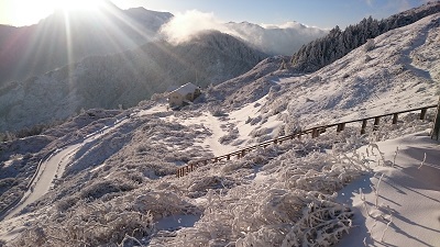
The total length of the Nenggao Cross-Ridge Trail is 26.5 kilometers. The mileage of the Cross-Ridge Trail is calculated from the west section Nantou Tunyuan trail entrance (0 kilometers) to the east section trail entrance at 26.5 kilometers as the trail end. The Guangbei Babiao Monument is located at 15.5 kilometers of the Cross-Ridge Trail. It is the crossing point of the Cross-Ridge Trail through the Central Mountain Range and the dividing point between the west and east sections of the Cross-Ridge Trail. Therefore, the east section of the Nenggao Cross-Ridge Trail refers to the section from the east section trail entrance at an altitude of 1582 meters to the Guangbei Babiao Monument at an altitude of 2787 meters. It is 11 kilometers long and has an altitude increase of 1205 meters. On the way, it passes through Wujia Bengshan, Huilin Line Protection Station and Shanghuilin Suspension Bridge.
06/21 Sun.
Open
25°
23° / 27°
花蓮縣 / 秀林鄉
More
Weather Forecast
|
09.16
Thur.
|
09.17
Fri.
|
09.18
Sat.
|
09.19
Sun.
|
09.20
Mon.
|
09.21
Tue.
|
09.22
Wed.
|
|
|---|---|---|---|---|---|---|---|
| Temperature |
23 ° / 27 °
|
23 ° / 28 °
|
23 ° / 27 °
|
22 ° / 27 °
|
23 ° / 27 °
|
23 ° / 28 °
|
23 ° / 27 °
|
| Feel like | 27 ° / 31 ° | 25 ° / 32 ° | 25 ° / 31 ° | 25 ° / 32 ° | 25 ° / 32 ° | 24 ° / 32 ° | 25 ° / 31 ° |
|
Probability of Precipitation |
20 % | 20 % | 30 % | - | - | - | - |
| Relative Humidity | 86 % | 88 % | 87 % | 86 % | 82 % | 82 % | 80 % |
|
Wind speed Wind direction |
2
S
|
2
SW
|
2
SW
|
2
SW
|
2
W
|
2
W
|
2
E
|
| UVI |
8
Very High
|
9
Very High
|
9
Very High
|
10
Very High
|
10
Very High
|
10
Very High
|
10
Very High
|
|
Sunrise Sunset |
|
|
|
|
|
|
|
Central Weather Bureau|Update Time:2021/09/16 11:17
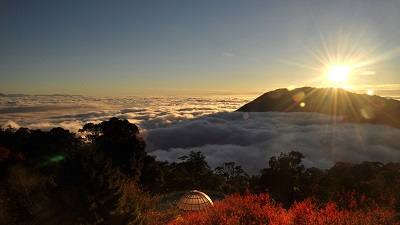
Sioulin Township, Hualien County
Nenggao Cross-Ridge Trail-East Sec.
Learn about the Trail
Trail difficulty level
| Hiking Level |
|
|
|
|
|
|
|
||||||||||||||||||||||||||||||||||||||||||
|---|---|---|---|---|---|---|---|---|---|---|---|---|---|---|---|---|---|---|---|---|---|---|---|---|---|---|---|---|---|---|---|---|---|---|---|---|---|---|---|---|---|---|---|---|---|---|---|---|---|
| Target | General Public | General Public | Those who have better physical energy | Beginner mountain climber with good physical energy and map literacy. | Open to those who have good physical strength, map reading skills, and wild survival skills. | Open to well-trained mountain climbers. | Open to well-trained mountain climbers. | ||||||||||||||||||||||||||||||||||||||||||
| Elevation | Gently sloping area | In recreational areas, close to settlements or about 1,000 meters above sea level. | In recreational areas, close to settlements or between 1,000~2,000 meters above sea level. | Remote areas or between 2,000 to 3,000 meters above sea level | Remote areas, wilderness, or between 2,000 to 3,000 meters above sea level | Remote areas, wilderness, or more than 3,000 meters above sea level | Remote areas, wilderness, or more than 3,000 meters above sea level | ||||||||||||||||||||||||||||||||||||||||||
| Required Time | It takes half to one day. | It takes half to one day. | It can be done within one day. | It takes one or more days. | Overnight preparation required. | It takes up to three days. | It takes up to three days. | ||||||||||||||||||||||||||||||||||||||||||
| Equipment | Light backpacking (water and small amount of food) | Light backpacking (water and small amount of food) | Light backpacking (water and proper amount of food) | Overnight preparation required. (e.g. drinking water, food, map, warm clothing, first-aid medicine, etc.) Application for entrance permission in advance is required if there is access control. | Comprehensive Mountaineering Gear Required. (e.g. food, drinking water, cooking utensils, map, warm clothing, flashlight, sleeping bag, tent, etc.) Application for entrance permission in advance is required if there is access control. | Comprehensive Mountaineering Gear Required. (e.g. food, drinking water, cooking utensils, map, warm clothing, flashlight, sleeping bag, tent, etc.) Application for entrance permission in advance is required if there is access control. | Comprehensive Mountaineering Gear Required. (e.g. food, drinking water, cooking utensils, map, warm clothing, flashlight, sleeping bag, tent, etc.) Application for entrance permission in advance is required if there is access control. | ||||||||||||||||||||||||||||||||||||||||||
| Description | Flat hiking trails. Relatively even slopes with comprehensive facilities and smooth road surface. Accessible for handicapped assistive devices or baby strollers. | An open hiking trail with easy access. Relatively even slopes with comprehensive facilities and smooth road surface. It takes half a day or less than one day to complete. | An open hiking trail with easy access. Somewhat steep slope with some difficult sections, but has comprehensive facilities and smooth road surface. It takes less than one day to complete. | A hiking trail locates at remote area or with part of the route is in area which requires entrance permission. Application in advance is required. Part of the route is in relatively bad condition with steeper slopes, but basic facilities are provided. It takes one day or between one to three days to complete. | A hiking trail locates at remote area or with part of the route is in area which requires entrance permission. It’s located in high-altitude areas (higher than 3000 meters above sea level). The trail is relatively primitive, with steeper slopes and unstable weather conditions. Part of the route may be dangerous or difficult for climbers. It takes two to three days to complete. Lead from professionals is recommended. | A hiking trail locates at area with inconvenient traffic, and mostly with routes in area which requires entrance permission. It’s located in high-altitude areas (higher than 3000 meters above sea level). The trail is located at primitive area, with bad condition, steeper slopes, and unstable weather conditions. Many parts of the route may be dangerous or difficult for climbers. It takes three or more days to complete. Lead from professionals is recommended. | 1. Level 3, 4 or 5 trails when snow or ice accumulating 2. Informal trails, without clear subgrades or paths, belong to special routes such as original mountain trails, ancient trail relics, prospecting, or technical climbing. |
Hiking Level
Target
General Public
Elevation
Gently sloping area
Required Time
It takes half to one day.
Equipment
Light backpacking (water and small amount of food)
Description
Flat hiking trails. Relatively even slopes with comprehensive facilities and smooth road surface. Accessible for handicapped assistive devices or baby strollers.
Hiking Level
Target
General Public
Elevation
In recreational areas, close to settlements or about 1,000 meters above sea level.
Required Time
It takes half to one day.
Equipment
Light backpacking (water and small amount of food)
Description
An open hiking trail with easy access. Relatively even slopes with comprehensive facilities and smooth road surface. It takes half a day or less than one day to complete.
Hiking Level
Target
Those who have better physical energy
Elevation
In recreational areas, close to settlements or between 1,000~2,000 meters above sea level.
Required Time
It can be done within one day.
Equipment
Light backpacking (water and proper amount of food)
Description
An open hiking trail with easy access. Somewhat steep slope with some difficult sections, but has comprehensive facilities and smooth road surface. It takes less than one day to complete.
Hiking Level
Target
Beginner mountain climber with good physical energy and map literacy.
Elevation
Remote areas or between 2,000 to 3,000 meters above sea level
Required Time
It takes one or more days.
Equipment
Overnight preparation required. (e.g. drinking water, food, map, warm clothing, first-aid medicine, etc.)
Application for entrance permission in advance is required if there is access control.
Description
A hiking trail locates at remote area or with part of the route is in area which requires entrance permission. Application in advance is required. Part of the route is in relatively bad condition with steeper slopes, but basic facilities are provided. It takes one day or between one to three days to complete.
Hiking Level
Target
Open to those who have good physical strength, map reading skills, and wild survival skills.
Elevation
Remote areas, wilderness, or between 2,000 to 3,000 meters above sea level
Required Time
Overnight preparation required.
Equipment
Comprehensive Mountaineering Gear Required. (e.g. food, drinking water, cooking utensils, map, warm clothing, flashlight, sleeping bag, tent, etc.)
Application for entrance permission in advance is required if there is access control.
Description
A hiking trail locates at remote area or with part of the route is in area which requires entrance permission. It’s located in high-altitude areas (higher than 3000 meters above sea level). The trail is relatively primitive, with steeper slopes and unstable weather conditions. Part of the route may be dangerous or difficult for climbers. It takes two to three days to complete. Lead from professionals is recommended.
Hiking Level
Target
Open to well-trained mountain climbers.
Elevation
Remote areas, wilderness, or more than 3,000 meters above sea level
Required Time
It takes up to three days.
Equipment
Comprehensive Mountaineering Gear Required. (e.g. food, drinking water, cooking utensils, map, warm clothing, flashlight, sleeping bag, tent, etc.)
Application for entrance permission in advance is required if there is access control.
Description
A hiking trail locates at area with inconvenient traffic, and mostly with routes in area which requires entrance permission. It’s located in high-altitude areas (higher than 3000 meters above sea level). The trail is located at primitive area, with bad condition, steeper slopes, and unstable weather conditions. Many parts of the route may be dangerous or difficult for climbers. It takes three or more days to complete. Lead from professionals is recommended.
Hiking Level
Target
Open to well-trained mountain climbers.
Elevation
Remote areas, wilderness, or more than 3,000 meters above sea level
Required Time
It takes up to three days.
Equipment
Comprehensive Mountaineering Gear Required. (e.g. food, drinking water, cooking utensils, map, warm clothing, flashlight, sleeping bag, tent, etc.)
Application for entrance permission in advance is required if there is access control.
Description
1. Level 3, 4 or 5 trails when snow or ice accumulating
2. Informal trails, without clear subgrades or paths, belong to special routes such as original mountain trails, ancient trail relics, prospecting, or technical climbing.
Reachable by Vehicle
X:Cars、Microbus、Coach Bus
Mountain system
Central Mountain Range - Hehuan Mountain
Administer
Hualien Forest Dist. Office
Elevation
1,689 ~ 3,263 m
Service Line
+886 38325141
Altitude Difference
1,574 m
Huts
-
Length of the Trail
11 KM
Entry Permit
是
Trail type
-
Via Nature Reserve
No
Service Line
Vehicles can currently reach 10.5K on the connecting road, Qilai Road, and you need to hike from here. The heavy rains brought by typhoons Dusurui, Haikui, and Xiaoquan in 2012 have caused many landslides, so hikers must be careful when passing through.
Geologically Sensitive Area
Yes
Route planning
-
Debris Flow Torrents
No
Trail Track
Trail route
Trailhead / Trig
Mobile coverage
Observations (From iNaturalist)
Trailhead / Trig
Mobile coverage
Observations (From iNaturalist)
Nohko Cross-RidgeTrail
It is recommended to use three days and two nights to complete the entire route. You can enjoy the magnificent natural scenery and rich cultural and historical relics along the way.
On the first day, start from the west side of the Tunyuan trail entrance, pass the Fujimi Station Ruins, Unkai Line Protection Station, Onoue Station Ruins, Matsubara Station Ruins, Matsubara Charcoal Kiln Ruins and Nohko Waterfall and other attractions along the way, and stay overnight at Tianchi Villa 16 kilometers away, with an altitude of 2,860 meters.
On the second day, continue eastward
Passing the Central Mountain Range Crossing Point, you can see the wide alpine arrow bamboo grass slope and the Guangbei Babiao Monument, and then go down the eastern section of the Nohko Crossing Trail. The scenery of this section is quite magnificent. After passing the upper cypress forest suspension bridge across the Maruta River, the ancient road passes through the cypress forest and easily reaches the cypress forest protection station, which was originally the East Nohko Station. Walk in the temperate broad-leaved forest near the Hinoki Line Protection Station, and slowly descend to the starting point of the Wujia Bengshan High Route on a zigzag road. After rising 200 meters, you will reach the top of the mountain. When the view is good, you can clearly see the Qilai Peaks. Wujia Bengshan is located at the end of the eastern ridge of the northern peak of Nenggao. Because the Maruta River and the Shibata River converge here, the strong erosion force causes severe collapse. The Nenggao Crossing Road that originally crossed Wujia Bengshan has disappeared. Therefore, the Taipower Line B line protection line is used here to bypass Wujia Bengshan down to the east section of the trail entrance. The entire section of the Nenggao Cross-Ridge is 26.5 kilometers.
Taipower Line Protection Road Qilai Road is the external road of the eastern section of the Crossing Road. The total length from Qilai Road to the eastern section trail entrance is 19 kilometers. However, there are 11 collapses from Qilai Road 10.5 kilometers to the trail entrance of the Cross-Ridge, so vehicles can currently pass to 10.5 kilometers. From the trailhead, walk eastwards through Wanshan Hall and arrive at Qilai Villa at 14.6 km of Qilai Road. Camp for one night and leave Qilai Villa on the third day. End the walk at 10.5 km of Qilai Road, the end of the drive.
The second and third days are almost all downhill. However, the eastern section of the mountain road plus the distance where vehicles cannot pass Qilai Road, the total walking distance exceeds 20 kilometers. The middle section of Tianchang Tunnel collapsed and the wall must be crossed. Therefore, it is recommended to weigh the physical strength, time and weather conditions when arriving at Qilai Villa. If the conditions are good, you can consider going directly to the end of the drive the next day, but it is best to inquire about the road opening situation at Tongmen Police Station before departure.
D1
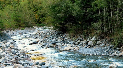
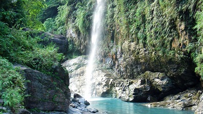
Tunyuan Trailhead 0K, Fujimi Station Site (H2100m), Unkai Line Protection Station 4.5K (H2360m), Songyuan Charcoal Kiln Site 8K (H2600m), Shuiyuan 8.7K, Nogao Falls 12K, Tianchi Villa 13K (H2860m).
D2
Tianchi Villa, Guangbei Babiao 15.5K (H2890m), Collapsed Land 19.2K, Hinoki Line Protection Station 20.3K, Hinoki Suspension Bridge Destroyed 20.7K, Wujia Collapse 23.3k 25.5K, East Trailhead 26.5K Taipower Qilai Road 19K), Wanshan Hall H1353m Qilai Road 15K), Qilai Villa Qilai Road 14K).
D3 Qilai Villa, driving end point Qilai Road 10.5K.
It is recommended to use three days and two nights to complete the entire route. You can enjoy the magnificent natural scenery and rich cultural and historical relics along the way.
On the first day, start from the west side of the Tunyuan trail entrance, pass the Fujimi Station Ruins, Unkai Line Protection Station, Onoue Station Ruins, Matsubara Station Ruins, Matsubara Charcoal Kiln Ruins and Nohko Waterfall and other attractions along the way, and stay overnight at Tianchi Villa 16 kilometers away, with an altitude of 2,860 meters.
On the second day, continue eastward
Passing the Central Mountain Range Crossing Point, you can see the wide alpine arrow bamboo grass slope and the Guangbei Babiao Monument, and then go down the eastern section of the Nohko Crossing Trail. The scenery of this section is quite magnificent. After passing the upper cypress forest suspension bridge across the Maruta River, the ancient road passes through the cypress forest and easily reaches the cypress forest protection station, which was originally the East Nohko Station. Walk in the temperate broad-leaved forest near the Hinoki Line Protection Station, and slowly descend to the starting point of the Wujia Bengshan High Route on a zigzag road. After rising 200 meters, you will reach the top of the mountain. When the view is good, you can clearly see the Qilai Peaks. Wujia Bengshan is located at the end of the eastern ridge of the northern peak of Nenggao. Because the Maruta River and the Shibata River converge here, the strong erosion force causes severe collapse. The Nenggao Crossing Road that originally crossed Wujia Bengshan has disappeared. Therefore, the Taipower Line B line protection line is used here to bypass Wujia Bengshan down to the east section of the trail entrance. The entire section of the Nenggao Cross-Ridge is 26.5 kilometers.
Taipower Line Protection Road Qilai Road is the external road of the eastern section of the Crossing Road. The total length from Qilai Road to the eastern section trail entrance is 19 kilometers. However, there are 11 collapses from Qilai Road 10.5 kilometers to the trail entrance of the Cross-Ridge, so vehicles can currently pass to 10.5 kilometers. From the trailhead, walk eastwards through Wanshan Hall and arrive at Qilai Villa at 14.6 km of Qilai Road. Camp for one night and leave Qilai Villa on the third day. End the walk at 10.5 km of Qilai Road, the end of the drive.
The second and third days are almost all downhill. However, the eastern section of the mountain road plus the distance where vehicles cannot pass Qilai Road, the total walking distance exceeds 20 kilometers. The middle section of Tianchang Tunnel collapsed and the wall must be crossed. Therefore, it is recommended to weigh the physical strength, time and weather conditions when arriving at Qilai Villa. If the conditions are good, you can consider going directly to the end of the drive the next day, but it is best to inquire about the road opening situation at Tongmen Police Station before departure.
D1
Tunyuan Trailhead 0K, Fujimi Station Site (H2100m), Unkai Line Protection Station 4.5K (H2360m), Songyuan Charcoal Kiln Site 8K (H2600m), Shuiyuan 8.7K, Nogao Falls 12K, Tianchi Villa 13K (H2860m).
D2
Tianchi Villa, Guangbei Babiao 15.5K (H2890m), Collapsed Land 19.2K, Hinoki Line Protection Station 20.3K, Hinoki Suspension Bridge Destroyed 20.7K, Wujia Collapse 23.3k 25.5K, East Trailhead 26.5K Taipower Qilai Road 19K), Wanshan Hall H1353m Qilai Road 15K), Qilai Villa Qilai Road 14K).
D3 Qilai Villa, driving end point Qilai Road 10.5K.
Reminders
Mountain Encyclopedia
Please click below to view information
Please check with the National Police Agency regarding mountain entry control. Please follow the National Police Agency's regulations to determine whether or not you will be allowed to enter the mountain.
[Hualien County Police Department Security Division] The East Section of Nenggao Mountain, which is under the jurisdiction of the Hualien Branch of the Forestry and Conservation Administration of the Council of Agriculture, Executive Yuan, has been opened to traffic after emergency maintenance, setting up signs on dangerous sections, and completing inventory. Our agency will cooperate with the application of mountain entry permits from now on. However, the section from the trailhead of the East Section of Nenggao Mountain to Tongmen (Mugu Muyu) has not been opened due to road landslides. Please avoid the aforementioned section when applying for mountain entry. Thank you.
Description of dangerous sections (please evaluate your physical condition, experience, and equipment before deciding whether to climb the mountain. In addition, this route is not suitable for solo climbing!!!
The external roads and trails were maintained in November 2018 for the collapsed parts. However, the landslide at 5.5K on Qilai Road on the external road made it impossible for vehicles to pass, so people had to walk there. Signs or paint marks have been added to the unknown sections of the eastern section of Nenggao Cross-Ridge Trail. The risky sections have been generally improved, but there are two sections with higher risks that require teammates to help each other: 23K collapsed terrain, the soil and rocks are soft and lack footholds, and experienced people need to pass first to find footholds. For those who are less experienced in crossing the terrain, they can separate the person and the bag and pass without the bag. Experienced people help to carry the bag for one more trip; and at 19.2 kilometers, due to the slippage of the roadbed, the soil and rocks are soft and there is no stable and reliable support for the rope at the downclimbing point. It cannot be improved this time. It is recommended that experienced people ensure and guide other teammates to climb up and down with their bare hands. For those who are less experienced in crossing the terrain, it is recommended that they practice rock climbing in normal times to increase their judgment of the terrain and experience in crossing the terrain.
Carry GPS positioning system and communication equipment
Please plan your itinerary properly and bring enough equipment and food for hiking. It is recommended to bring a global satellite positioning system (GPS) and communication equipment such as satellite phones, mobile phones, radios or equipment with satellite positioning functions such as personal location trackers (PLBs), etc., and bring enough batteries to ensure emergency communication.
Pass through danger zones quickly
The road conditions in the mountains are unstable. Please do not stop or take photos in dangerous places such as landslides or rockfall areas, and pay attention to your own safety at all times.
It is recommended to purchase mountaineering insurance
Mountain activities have certain risks. It is recommended that you purchase mountaineering insurance before departure. (Note: General travel insurance does not necessarily cover mountaineering accidents. It is recommended to read the policy carefully before purchasing. For mountaineering insurance, please refer to the following press release of the Financial Supervisory Commission and choose the appropriate policy to purchase)
Mountaineering safety information
For information on mountaineering safety knowledge, mountaineering equipment, map usage skills, etc., please see the mountaineering supply station webpage below. It is recommended to read it before the trip to ensure the safety of your outdoor activities.
【Pay special attention to altitude sickness】
The trail reaches an altitude of over 2,500 meters. Anyone may be at risk of mountain sickness. It is recommended to assess your physical and physiological condition before departure and prepare personal medicines. For an introduction to mountain sickness, please see the following article. For relevant knowledge on mountain medicine, please see the following video (produced by the Taiwan Wilderness Emergency Rescue Association).
Travel with a companion and do not take shortcuts
For your own safety, please travel with a group, follow the signs, do not take shortcuts or create your own route, and do not wander alone.
Itinerary arrangement
Nohko Cross-RidgeTrail
It is recommended to use three days and two nights to complete the entire route. You can enjoy the magnificent natural scenery and rich cultural and historical relics along the way.
On the first day, start from the west side of the Tunyuan trail entrance, pass the Fujimi Station Ruins, Unkai Line Protection Station, Onoue Station Ruins, Matsubara Station Ruins, Matsubara Charcoal Kiln Ruins and Nohko Waterfall and other attractions along the way, and stay overnight at Tianchi Villa 16 kilometers away, with an altitude of 2,860 meters.
On the second day, continue eastward
Passing the Central Mountain Range Crossing Point, you can see the wide alpine arrow bamboo grass slope and the Guangbei Babiao Monument, and then go down the eastern section of the Nohko Crossing Trail. The scenery of this section is quite magnificent. After passing the upper cypress forest suspension bridge across the Maruta River, the ancient road passes through the cypress forest and easily reaches the cypress forest protection station, which was originally the East Nohko Station. Walk in the temperate broad-leaved forest near the Hinoki Line Protection Station, and slowly descend to the starting point of the Wujia Bengshan High Route on a zigzag road. After rising 200 meters, you will reach the top of the mountain. When the view is good, you can clearly see the Qilai Peaks. Wujia Bengshan is located at the end of the eastern ridge of the northern peak of Nenggao. Because the Maruta River and the Shibata River converge here, the strong erosion force causes severe collapse. The Nenggao Crossing Road that originally crossed Wujia Bengshan has disappeared. Therefore, the Taipower Line B line protection line is used here to bypass Wujia Bengshan down to the east section of the trail entrance. The entire section of the Nenggao Cross-Ridge is 26.5 kilometers.
Taipower Line Protection Road Qilai Road is the external road of the eastern section of the Crossing Road. The total length from Qilai Road to the eastern section trail entrance is 19 kilometers. However, there are 11 collapses from Qilai Road 10.5 kilometers to the trail entrance of the Cross-Ridge, so vehicles can currently pass to 10.5 kilometers. From the trailhead, walk eastwards through Wanshan Hall and arrive at Qilai Villa at 14.6 km of Qilai Road. Camp for one night and leave Qilai Villa on the third day. End the walk at 10.5 km of Qilai Road, the end of the drive.
The second and third days are almost all downhill. However, the eastern section of the mountain road plus the distance where vehicles cannot pass Qilai Road, the total walking distance exceeds 20 kilometers. The middle section of Tianchang Tunnel collapsed and the wall must be crossed. Therefore, it is recommended to weigh the physical strength, time and weather conditions when arriving at Qilai Villa. If the conditions are good, you can consider going directly to the end of the drive the next day, but it is best to inquire about the road opening situation at Tongmen Police Station before departure.
D1
Tunyuan Trailhead 0K, Fujimi Station Site (H2100m), Unkai Line Protection Station 4.5K (H2360m), Songyuan Charcoal Kiln Site 8K (H2600m), Shuiyuan 8.7K, Nogao Falls 12K, Tianchi Villa 13K (H2860m).
D2
Tianchi Villa, Guangbei Babiao 15.5K (H2890m), Collapsed Land 19.2K, Hinoki Line Protection Station 20.3K, Hinoki Suspension Bridge Destroyed 20.7K, Wujia Collapse 23.3k 25.5K, East Trailhead 26.5K Taipower Qilai Road 19K), Wanshan Hall H1353m Qilai Road 15K), Qilai Villa Qilai Road 14K).
D3 Qilai Villa, driving end point Qilai Road 10.5K
Mountain climbing is at your own risk
1. This route is a long hiking trail, which takes a long time to complete. Therefore, climbers should have rich hiking experience, sufficient equipment, skills and physical strength to engage in hiking activities on this advanced route.
2. This route is mainly an early-built trail with few users. In addition, due to multiple typhoons, most of the suspension bridges and trestle bridges along the route have been damaged, so you must be careful when passing through. There are also several large collapses along the trail, which makes walking more difficult.
3. The eastern section of the trail is humid and overgrown with weeds. There are many leeches, snakes, hornets and biting cats. You should be especially careful when walking here.
4. In response to the Executive Yuan's policy, those who engage in hiking activities should take the initiative to evaluate their own experience, equipment, technical ability, physical fitness, weather conditions, and confirm the risks brought by the activities, and should bear their own safety responsibilities. Because mountain trails are easily affected by the natural environment, causing unpredictable damage or blockages, climbers are advised not to force their way through when they have concerns about safety, in order to maintain their own safety. We welcome you to provide relevant road condition information to benefit fellow climbers.
Pet policy
When traveling with pets, please tie them up properly, or put them in a cage, bag, or cart to prevent them from chasing or scaring wild animals. Please also clean up their excrement and avoid contact with wild animals.
Travel Guide

Travel Guide
Nearby Attractions