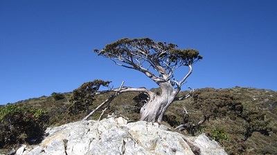
Guanshanling Mountain Trail rises up close to 450m above sea level. Some sections are steep and visitors have to climb up rocky cliffs or hold on to the rope to move up and down. It is not an easy walk. The trail begins from a set of wooden steps. After going uphill to the 0.5km mark, visitors will begin to walk on the precipitous and open ridgeline. The spectacular high-mountain view of “clouds swimming in the mountains and the mountain moves in the clouds” is right there. The trail passes by high-altitude forests and vegetation and the landscape is magnificent. The soaring hemlock and spruce forests, the proudly-still-standing white remains of burnt woods and the Jade Mountain arrow bamboo grassland in the initial succession all interpret the richness and vitality of high-mountain ecology in Taiwan. Right between bare rocks in the cliff by the trail, one can see green vegetation extending its territory with the greatest possibility. The mountain path is rugged and precipitous, extra caution must be taken to walk on this beautiful trail in a mountain ranking in the Top 100 High Mountains in Taiwan. Not far from the 0.5km mark of the trail is a monument carrying the wording of “In memory of Xu Asong, our fellow mountain climber” to commemorate Mr. Xu who fell down the mountain and died in an accident as well as to remind visitors to be extra careful when climbing this mountain.
06/21 Sun.
Open
26°
23° / 29°
臺東縣 / 海端鄉
More
Weather Forecast
|
09.16
Thur.
|
09.17
Fri.
|
09.18
Sat.
|
09.19
Sun.
|
09.20
Mon.
|
09.21
Tue.
|
09.22
Wed.
|
|
|---|---|---|---|---|---|---|---|
| Temperature |
23 ° / 29 °
|
22 ° / 30 °
|
22 ° / 30 °
|
22 ° / 30 °
|
22 ° / 30 °
|
22 ° / 30 °
|
22 ° / 30 °
|
| Feel like | 27 ° / 34 ° | 25 ° / 35 ° | 25 ° / 35 ° | 25 ° / 35 ° | 25 ° / 35 ° | 25 ° / 34 ° | 25 ° / 35 ° |
|
Probability of Precipitation |
70 % | 20 % | 20 % | - | - | - | - |
| Relative Humidity | 87 % | 89 % | 86 % | 86 % | 86 % | 85 % | 86 % |
|
Wind speed Wind direction |
2
SW
|
2
NW
|
2
NW
|
2
NW
|
2
NW
|
2
NW
|
2
NW
|
| UVI |
9
Very High
|
9
Very High
|
10
Very High
|
10
Very High
|
10
Very High
|
10
Very High
|
10
Very High
|
|
Sunrise Sunset |
|
|
|
|
|
|
|
Central Weather Bureau|Update Time:2021/09/16 11:17
Haiduan Township, Taitung County
Guanshan-Lingshan Trail
Learn about the Trail
Application
Transportation
Eastern route
Take Provincial highway no.9. Transfer to Provincial Highway no.20 near Chihshan Town of Taitung County, and go for about 5 kilometers. Transfer to Provincial Highway no. 20 and take Southern Cross-island Highway. Reach Yakou at 146 kilometers of Southern Cross-island Highway. The entrance of Mt. Guanshanling hiking trail is next to Yakou.
Western route
Start from Guan Tain system of National Highway no.3. Transfer to Expressway no. 84 to Yujing, and then take shared line of Provincial Highway no.3 and Provincial highway no. 20 to Bei Jai and Nan Hua, passing through Jiashiang, Baolai, Taoyuan, Meishan, Tianchih, and reach Yakou. Hiking trail entrance of Mt. Guanshan Ling is next to Yakou.
None.
None.
Trail difficulty level
| Hiking Level |
|
|
|
|
|
|
|
||||||||||||||||||||||||||||||||||||||||||
|---|---|---|---|---|---|---|---|---|---|---|---|---|---|---|---|---|---|---|---|---|---|---|---|---|---|---|---|---|---|---|---|---|---|---|---|---|---|---|---|---|---|---|---|---|---|---|---|---|---|
| Target | General Public | General Public | Those who have better physical energy | Beginner mountain climber with good physical energy and map literacy. | Open to those who have good physical strength, map reading skills, and wild survival skills. | Open to well-trained mountain climbers. | Open to well-trained mountain climbers. | ||||||||||||||||||||||||||||||||||||||||||
| Elevation | Gently sloping area | In recreational areas, close to settlements or about 1,000 meters above sea level. | In recreational areas, close to settlements or between 1,000~2,000 meters above sea level. | Remote areas or between 2,000 to 3,000 meters above sea level | Remote areas, wilderness, or between 2,000 to 3,000 meters above sea level | Remote areas, wilderness, or more than 3,000 meters above sea level | Remote areas, wilderness, or more than 3,000 meters above sea level | ||||||||||||||||||||||||||||||||||||||||||
| Required Time | It takes half to one day. | It takes half to one day. | It can be done within one day. | It takes one or more days. | Overnight preparation required. | It takes up to three days. | It takes up to three days. | ||||||||||||||||||||||||||||||||||||||||||
| Equipment | Light backpacking (water and small amount of food) | Light backpacking (water and small amount of food) | Light backpacking (water and proper amount of food) | Overnight preparation required. (e.g. drinking water, food, map, warm clothing, first-aid medicine, etc.) Application for entrance permission in advance is required if there is access control. | Comprehensive Mountaineering Gear Required. (e.g. food, drinking water, cooking utensils, map, warm clothing, flashlight, sleeping bag, tent, etc.) Application for entrance permission in advance is required if there is access control. | Comprehensive Mountaineering Gear Required. (e.g. food, drinking water, cooking utensils, map, warm clothing, flashlight, sleeping bag, tent, etc.) Application for entrance permission in advance is required if there is access control. | Comprehensive Mountaineering Gear Required. (e.g. food, drinking water, cooking utensils, map, warm clothing, flashlight, sleeping bag, tent, etc.) Application for entrance permission in advance is required if there is access control. | ||||||||||||||||||||||||||||||||||||||||||
| Description | Flat hiking trails. Relatively even slopes with comprehensive facilities and smooth road surface. Accessible for handicapped assistive devices or baby strollers. | An open hiking trail with easy access. Relatively even slopes with comprehensive facilities and smooth road surface. It takes half a day or less than one day to complete. | An open hiking trail with easy access. Somewhat steep slope with some difficult sections, but has comprehensive facilities and smooth road surface. It takes less than one day to complete. | A hiking trail locates at remote area or with part of the route is in area which requires entrance permission. Application in advance is required. Part of the route is in relatively bad condition with steeper slopes, but basic facilities are provided. It takes one day or between one to three days to complete. | A hiking trail locates at remote area or with part of the route is in area which requires entrance permission. It’s located in high-altitude areas (higher than 3000 meters above sea level). The trail is relatively primitive, with steeper slopes and unstable weather conditions. Part of the route may be dangerous or difficult for climbers. It takes two to three days to complete. Lead from professionals is recommended. | A hiking trail locates at area with inconvenient traffic, and mostly with routes in area which requires entrance permission. It’s located in high-altitude areas (higher than 3000 meters above sea level). The trail is located at primitive area, with bad condition, steeper slopes, and unstable weather conditions. Many parts of the route may be dangerous or difficult for climbers. It takes three or more days to complete. Lead from professionals is recommended. | 1. Level 3, 4 or 5 trails when snow or ice accumulating 2. Informal trails, without clear subgrades or paths, belong to special routes such as original mountain trails, ancient trail relics, prospecting, or technical climbing. |
Hiking Level
Target
General Public
Elevation
Gently sloping area
Required Time
It takes half to one day.
Equipment
Light backpacking (water and small amount of food)
Description
Flat hiking trails. Relatively even slopes with comprehensive facilities and smooth road surface. Accessible for handicapped assistive devices or baby strollers.
Hiking Level
Target
General Public
Elevation
In recreational areas, close to settlements or about 1,000 meters above sea level.
Required Time
It takes half to one day.
Equipment
Light backpacking (water and small amount of food)
Description
An open hiking trail with easy access. Relatively even slopes with comprehensive facilities and smooth road surface. It takes half a day or less than one day to complete.
Hiking Level
Target
Those who have better physical energy
Elevation
In recreational areas, close to settlements or between 1,000~2,000 meters above sea level.
Required Time
It can be done within one day.
Equipment
Light backpacking (water and proper amount of food)
Description
An open hiking trail with easy access. Somewhat steep slope with some difficult sections, but has comprehensive facilities and smooth road surface. It takes less than one day to complete.
Hiking Level
Target
Beginner mountain climber with good physical energy and map literacy.
Elevation
Remote areas or between 2,000 to 3,000 meters above sea level
Required Time
It takes one or more days.
Equipment
Overnight preparation required. (e.g. drinking water, food, map, warm clothing, first-aid medicine, etc.)
Application for entrance permission in advance is required if there is access control.
Description
A hiking trail locates at remote area or with part of the route is in area which requires entrance permission. Application in advance is required. Part of the route is in relatively bad condition with steeper slopes, but basic facilities are provided. It takes one day or between one to three days to complete.
Hiking Level
Target
Open to those who have good physical strength, map reading skills, and wild survival skills.
Elevation
Remote areas, wilderness, or between 2,000 to 3,000 meters above sea level
Required Time
Overnight preparation required.
Equipment
Comprehensive Mountaineering Gear Required. (e.g. food, drinking water, cooking utensils, map, warm clothing, flashlight, sleeping bag, tent, etc.)
Application for entrance permission in advance is required if there is access control.
Description
A hiking trail locates at remote area or with part of the route is in area which requires entrance permission. It’s located in high-altitude areas (higher than 3000 meters above sea level). The trail is relatively primitive, with steeper slopes and unstable weather conditions. Part of the route may be dangerous or difficult for climbers. It takes two to three days to complete. Lead from professionals is recommended.
Hiking Level
Target
Open to well-trained mountain climbers.
Elevation
Remote areas, wilderness, or more than 3,000 meters above sea level
Required Time
It takes up to three days.
Equipment
Comprehensive Mountaineering Gear Required. (e.g. food, drinking water, cooking utensils, map, warm clothing, flashlight, sleeping bag, tent, etc.)
Application for entrance permission in advance is required if there is access control.
Description
A hiking trail locates at area with inconvenient traffic, and mostly with routes in area which requires entrance permission. It’s located in high-altitude areas (higher than 3000 meters above sea level). The trail is located at primitive area, with bad condition, steeper slopes, and unstable weather conditions. Many parts of the route may be dangerous or difficult for climbers. It takes three or more days to complete. Lead from professionals is recommended.
Hiking Level
Target
Open to well-trained mountain climbers.
Elevation
Remote areas, wilderness, or more than 3,000 meters above sea level
Required Time
It takes up to three days.
Equipment
Comprehensive Mountaineering Gear Required. (e.g. food, drinking water, cooking utensils, map, warm clothing, flashlight, sleeping bag, tent, etc.)
Application for entrance permission in advance is required if there is access control.
Description
1. Level 3, 4 or 5 trails when snow or ice accumulating
2. Informal trails, without clear subgrades or paths, belong to special routes such as original mountain trails, ancient trail relics, prospecting, or technical climbing.
Reachable by Vehicle
X:Cars、Microbus、Coach Bus
Mountain system
Southern Cross-island Highway 3 Mountains
Administer
Taitung Forest Dist. Office
Elevation
2,722 ~ 3,176 m
Service Line
+886 89324121
Altitude Difference
454 m
Huts
-
Length of the Trail
-
Entry Permit
No
Trail type
Linear two-way
Via Nature Reserve
No
Service Line
Soil trail,Rock wall
Geologically Sensitive Area
Yes
Route planning
-
Debris Flow Torrents
No
Trail Track
Trail route
Trailhead / Trig
Mobile coverage
Observations (From iNaturalist)
Trailhead / Trig
Mobile coverage
Observations (From iNaturalist)
Reminders
Go with your companions and don't take shortcuts.
To ensure your safety, please go with your companions, follow the indicators, do not take shortcuts or self-directed routes, and do not leave your team and walk alone.
Carry Global Positioning System and communication equipment
For hiking, please plan your trip and bring enough equipment and food with you. It is suggested that you should carry Global Positioning System (GPS) and communication equipment such as a satellite phone, mobile phone, radio or satellite positioning equipment such as Personal Locator Beacon (PLB), etc., and should carry enough batteries to ensure emergency communication.
Quickly pass dangerous areas
The road condition in the mountainous area is unstable. Please do not stay or take pictures in dangerous areas such as collapsed or falling rocks and pay attention to your own safety at any time.
It is recommended to complete the mountaineering insurance
There are certain risks in mountain activities. It is recommended that you should complete mountaineering insurance before departure. (Note: General travel insurance does not necessarily cover mountaineering accidents. Please refer to the policy details before applying for insurance. For the mountaineering insurance, please refer to the following instructions in Financial Supervisory Commission's press release and choose the appropriate insurance.)
Information on mountaineering safety
For information on mountaineering safety, mountaineering equipment, and tips for using maps, please visit the website http://goo.gl/QUnv152u. It is recommended to read the information before the trip to ensure your outdoor activities are safe.
Travel Guide

Travel Guide
Featured Landscape

I bow to the mountains
Source|臺東分署
Although the entire trail is only 1.5 kilometers long, the one-way climb is nearly 450 meters. Some sections are steep and require climbing cliffs and rocks, holding on to ropes to go up and down, so the journey is not easy. The trail climbs steeply to the 0.5-kilometer mark, where you begin walking on a steep ridge with a wide view. The magnificent mountain scenery of "clouds swimming in the mountains and mountains walking in the clouds" is in full view.

Be careful when walking on the trail
Source|臺東分署
As the mountain trail is rugged and steep, one must be very careful when walking on this beautiful Hundred Peaks Trail. Not far from the trail, 0.5 kilometers away, there is a "Memorial to the Late Xu Gong A Song Mountain Friend Who Died" to commemorate the mountain friend who accidentally fell into the valley and died. It also reminds tourists to be careful and pay attention to safety when climbing this mountain.

Triangulation point at 3176 meters
Source|臺東分署
The high-altitude forest vegetation and terrain along the trail are diverse and magnificent. Whether it is the towering hemlock and spruce forests, the proudly standing whitewood forests, or the early stage of succession of the Yushan arrow bamboo grassland, they all interpret the richness and vitality of Taiwan's alpine ecology. Just between the cliffs and bare rocks beside the trail, you can see green vegetation expanding the territory of life to the greatest extent possible.
Nearby Attractions